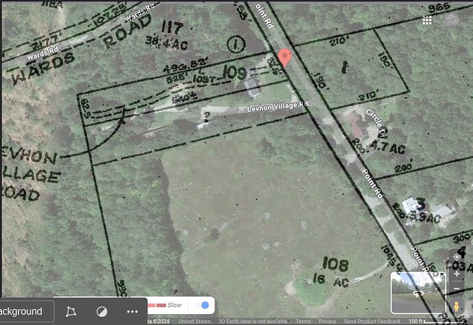
I am trying to figure out the acres of this plot of land based on what the deed states ( below) and could really use some help! The lot shape is shown in the attached picture ( Lot 109)
“A certain lot or parcel of land situated in the Town , Bound and 'discribed/as follows to wit: Beginning at the south west corner of the Blanch Salisbury lot on the East side of the Peter Jordan lot so called running South Five (5). rods on the Jordan said line more or less, Thence East Thirty Nine (39) rods more or less to the Road that leads to the Pond, thence North Five (5) rods, more or less-North on said road to the Blanch Salisbury south line, Thence East on said line Thirty Two (32) rods to the Place of beginning at the said Jordan East line”
you’d need a real survey to get an actual answer (town GIS can’t be 100% relied on) but it looks to me like 496’ deep x 82’ wide so 40-41k sq ft or just under an acre 0.93(ish) acres
Thank you Westwart.
That is around what I am coming up with which makes no sense with the lot (109) being so small.
There was also a boundary agreement between lot 108 and 109 for said property which may have widened the lot but it only gives a length from the steel rod at the street then west following what was a wire fence 576ft and no width is provided. I’m wondering if the lot with a “?” next to lot 109 ( the lot in the deed) is the extended boundary line…
As you can see based on the tax lot map the road would be going straight through the house and half of the mobile homes would not fit on the property. So you can see my dilemma and surveyors are 7+ months out at this point…
